
Wake the Wild
Caleb Wagner

This design aims to raise awareness of local ecosystems by re-connecting humans to the wild. Early inspiration for this design came from the desire to preserve native wildlife and provide extreme recreational activities. This site has been designed to allow for continuous education and research, preserve native ecosystems, and surround visitors with nature. Through the raised pedestrian bridge, residents and visitors to Manhattan have the opportunity to safely travel from the Manhattan Train Depot across the Kansas River to Fairmont Park. This also allows for minimal interruption of wildlife on site. This design creates more opportunity for adventure in Manhattan through the proposed ropes course, the introduction of camping spaces in Fairmont Park, an advanced terrain bike trail, and a new skate park underneath the bridge.
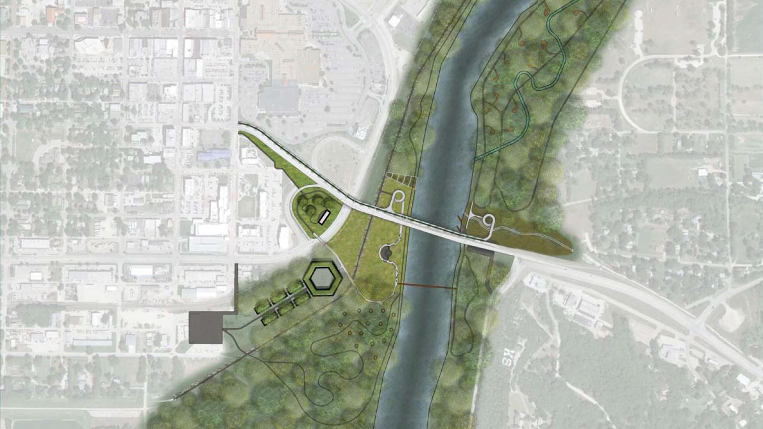
Figure 7.1 Site Plan
Th e proposed Bee Preserve and Research Center Courtyard respects the nearby wildlife habitats and provides opportunity for weekend activities such as an art show or farmers market.

Figure 7.2 Kaw River Valley Wildlife Research Center

Figure 7.3 ADA Accessible Pedestrian Bridge

Figure 7.4 Woodland Bridge
The proposed pedestrian bridge creates educational and recreational opportunities for visitors. The elevated path allows for minimal human disturbance of the wildlife below. This area of the bridge provides a unique tree canopy experience for users, including glass panes in the walking surface of the bridge allowing for 360 degrees of exposure to the surrounding wildlife.

Figure 7.5 Repurposed Circuation
The existing pedestrian route along Highway 177 is widened by reducing westbound traffic to one lane. This reduction will help eliminate the danger of high speed traffic. The inclusion of a planting buffer separates vehicular traffic from the pedestrian traffic, creating a safe pedestrian access route and provides a comfortable space to view the Kansas River ecosystems.
References
Figure 7.1
Little Bluestem Built Work. ND. Photo by Native Plant Associates. Courtesy of Native Plant Associates. Accessed April 2017. http://nativeplantassociates.com/sandplain- grassland-community/index.php/2011/04/little-bluestem/India Basin Shoreline Park Plan. ND. Photo by Gustafson Guthrie Nichols. Courtesy of Gustafson Guthrie Nichols. Accessed April 2017. http://www.ggnltd.com/india-basin-shoreline-park/Wetlands in a Desert. ND. Photo by Bob London. Courtesy of Shore Fishermans Corner. Accessed April 2017. http://www.shorefi shermanscorner.com/Gallery_Prairie_ GrassLandscapes_1.html Prairie Wildfl owers. ND. Photo by Project Eden. Courtesy of Project Eden. Accessed April 2017. http://www.project-eden.org/ecological-restoration/tallgrass-prairies/“Kansas River, Mahattan Kansas.” 39°10’30.49”N and 96°33’14.89”W. Google Earth 2016-2017. Accessed April 2017.
Figure 7.2
Leaf covered woodland fl oor on Walington Hill. 2009. Photo by Steve Daniels. Courtesy of Geograph. Accessed April 2017. https://commons.wikimedia.org/wiki/File:Leaf_ covered_woodland_fl oor_on_Watlington_Hill_-_geograph. org.uk_-_1288813.jpgDriveable Drainage. ND. Photo by Design Ideas & Decors. Courtesy of Design Ideas & Decors. Accessed April 2017. http://design.syrupdenver.com/driveway-ideas/driveway- drainage/Doe in the Snow. ND. Photo by Odette Toilette. Courtesy of Odette Toilette. Accesed April 2017. http://www.odettetoilette.com/tag/4160-tuesdays/Michigan Farmers Market. ND. Photo by Great Lakes Echo. Courtesy of Great Lakes Echo. Accessed April 2017. http://greatlakesecho.org/2017/03/10/fl uctuating-weather- complicates-harvesting-for-michigan-farmers/Geese: Lessons in Teamwork. 2012. Photo by Faithfood Blog. Courtesy of Faithfood Blog. Accessed April 2017. http://faithfood.net/blog/?p=489Cervatillo De Ciervo Cola Blanca. ND. Photo by Deer Worlds. Courtesy of Deer Worlds. Accessed April 2017. http://www.deerworlds.com/es/cervatillo-de-ciervo-cola-blanca/House for Trees. ND. Photo by Vo Trong Nghia Architects. Courtesy of Vo Trong Nghia Architects. Accessed April 2017. http://votrongnghia.com/projects/house-for-trees/
Figure 7.3
Little Bluestem Built Work. ND. Photo by Native Plant Associates. Courtesy of Native Plant Associates. Accessed April 2017. http://nativeplantassociates.com/sandplain- grassland-community/index.php/2011/04/little-bluestem/India Basin Shoreline Park Plan. ND. Photo by Gustafson Guthrie Nichols. Courtesy of Gustafson Guthrie Nichols. Accessed April 2017. http://www.ggnltd.com/india-basin-shoreline-park/Wetlands in a Desert. ND. Photo by Bob London. Courtesy of Shore Fishermans Corner. Accessed April 2017. http://www.shorefi shermanscorner.com/Gallery_Prairie_Grass_Landscapes_1.htmlPrairie Wildfl owers. ND. Photo by Project Eden. Courtesy of Project Eden. Accessed April 2017. http://www.project-eden.org/ecological-restoration/tallgrass-prairies/“Kansas River, Mahattan Kansas.” 39°10’30.49”N and 96°33’14.89”W. Google Earth 2016-2017. Accessed April 2017.
Figure 7.4
Doe in the Snow. ND. Photo by Odette Toilette. Courtesy of Odette Toilette. Accesed April 2017. http://www.odettetoilette.com/tag/4160-tuesdays/Adobe Photoshop.
Figure 7.5
Frost Kennels of Ohio. ND. Photo by Tony Webster. Courtesy of Flickr Hive Mind. Accessed April 2017. https://hiveminer.com/Tags/fremont,ohio/Interesting Colonial Man Statue. 2014. Photo by Pasagere. Courtesy of Pixabay. Accessed April 2017. https://pixabay.com/en/statue-reading-man-sitting-934500/