
People, Nature, & the River
Jacob Johnson
Life is better when people get in touch with nature and the river, bringing them back to their roots. Th e aim of this design is to connect people to the natural environments of the Kansas River. Th e areas of focus are the riverfront, the mixed-use building, and the connection of the two. First, the riverfront engages people with the river, bringing them to the water’s edge. Seating, fi re pits, trails, and an amphitheater are a few of the amenities proposed here. A few areas at the riverfront are the Promenade, the stream channel, and the Islands. Second, the mixed-use building serves as a connection to downtown Manhattan and Linear Trail. Residential, commercial, and cultural uses would be utilized. Finally, a pedestrian bridge is proposed to create a safe, direct connection from the riverfront to downtown.
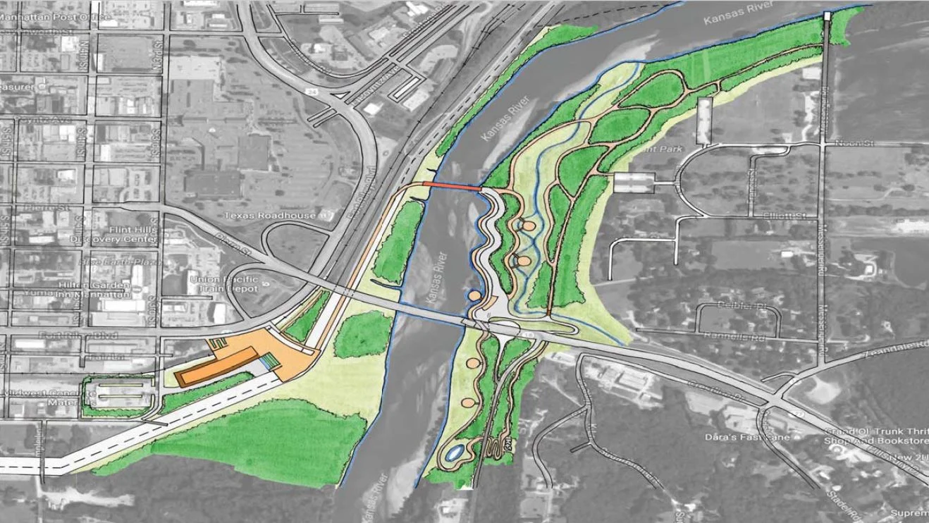
Figure 12.1 Site Plan

Figure 12.2 Riverfront View

Figure 12.3 Riverfront Section
The stream channel is a re-routed stream, which exists currently on site. The stream is an element of the riverfront design, which acts as a filtration system for contaminants in the water runoff . The results of this stream causes improved water quality for the site but also the Kansas River. Another benefit of the stream channel is that it provides wildlife habitat.

Figure 12.4 Th e Stream Channel
The Islands are a series of spaces that are separate from the Promenade. They are located along the stream channel and are connected to the riverfront via footbridges. They also provide places for picnicking, swinging, and hammocking. These spaces promote tranquility and relaxation.

Figure 12.5 Th e Islands
References
Figure 12.1
“Manhattan, KS K-177 Bridge.” 39 10’31.11” N and 96 33’08.62”. Google Earth. 8/12/2014. 4/5/2017. Johnson, Jacob. Manhattan Riverfront Site Plan. 2017. Pencil on trace. 15 in. x 20 in. Modifi ed in Photoshop, 2017.
Figure 12.2
Johnson, Jacob. 2017, color photo. Photos of Kansas River. Modifi ed in Photoshop, 2017. Unknown Author. color photo. Photo of Owensboro, KY Riverfront. Available from Google Images. Modifi ed in Photoshop, 2017.
Unknown Author. color photo. Photo of kayakers. Available from Google Images.Modifi ed in Photoshop, 2017.
Unknown Author. color photo. Photo of oak trees. Available from Google Images. Modifi ed in Photoshop, 2017.
Unknown Author. color photo. Photo of people walking. Available from Google Images. Modifi ed in Photoshop, 2017.
Figure 12.3
Johnson, Jacob. Riverfront Section. 2017. Pen on trace. 30 in. x 15 in. Modifi ed in Photoshop, 2017.
Figure 12.4
Johnson, Jacob. Th e Stream Channel. 2017. Pencil on paper. 8 in. x 10 in. Modifi ed in Photoshop, 2017.
Unknown Author. color photo. Photo of prairie grasses. Available from Google Images. Modifi ed in Photoshop, 2017.
Unknown Author. color photo. Photo of stream. Available from Google Images. Modifi ed in Photoshop, 2017.
Unknown Author. color photo. Photo of willow tree. Available from Google Images. Modifi ed in Photoshop, 2017.
Unknown Author. color photo. Photo of oak trees. Available from Google Images. Modifi ed in Photoshop, 2017.
Figure 12.5
Johnson, Jacob. Th e “Islands”. 2017. Pencil on paper. 8 in. x 10 in. Modifi ed in Photoshop, 2017.
Unknown Author. color photo. Photo of willow tree. Available from Google Images. Modifi ed in Photoshop, 2017.